
Essay Assignment: Leveraging ArcGIS for Urban Planning in Smart Cities
In the Essay
Introduction
In today’s rapidly growing cities, the need for smart urban planning has never been greater. Planners, policymakers, and city developers are increasingly turning to ArcGIS, Esri’s powerful geographic information system (GIS) software, to design more efficient, sustainable, and resilient cities. ArcGIS goes far beyond simple mapping—it is a dynamic platform that enables data-driven decision-making through advanced tools for data collection, spatial analysis, visualization, and collaboration.
By integrating diverse datasets such as population demographics, infrastructure networks, land-use patterns, and environmental indicators, ArcGIS helps urban planners gain a holistic view of complex urban ecosystems. This AI-powered GIS technology not only improves efficiency in planning but also supports smart city development, disaster preparedness, and sustainable growth strategies.
In this Leveraging ArcGIS for Urban Planning in Smart Cities Essay, we’ll explore how the software transforms modern city design, empowers decision-makers with real-time insights, and plays a central role in building the smart cities of the future.
The Role of ArcGIS in Modern Urban Planning
ArcGIS, a powerful suite of geographic information system (GIS) software developed by Esri, has become an indispensable tool in modern urban planning. Its capabilities extend far beyond traditional mapping, offering a comprehensive platform for data collection, analysis, visualization, and collaboration. By integrating diverse datasets—from demographic information and infrastructure networks to environmental factors and land-use patterns—ArcGIS provides urban planners with a holistic understanding of complex urban environments.
Key Features of ArcGIS Urban for Planning:
ArcGIS Urban, a specialized web-based solution within the ArcGIS ecosystem, streamlines the urban planning and design process through several key features:
- 3D Scenario Modeling: This feature allows planners to design and compare alternative development scenarios in a 3D environment. It enables the visualization of proposed changes, evaluation of their impacts, and testing of regulations, facilitating informed decision-making and stakeholder engagement. This capability is crucial for assessing the visual and spatial implications of new developments, ensuring they align with urban design principles and community needs.
- Data-Driven Analysis: ArcGIS Urban empowers planners to unlock the power of urban analytics for 3D scenario modeling. It facilitates the calculation of proposal impacts in real-time, identification of areas with potential for development, and leveraging existing GIS data for comprehensive analysis. This analytical prowess supports evidence-based planning, allowing for the evaluation of key performance indicators such as population density, job creation, and energy consumption.
- Project e-Submission: This feature accelerates the review and approval of proposed developments. It allows for the sketching and uploading of 3D models, review of proposals with integrated tools, and tracking of project status. This digital workflow enhances efficiency, reduces administrative burdens, and promotes transparency in the development review process.
- Collaborative Urban Planning: ArcGIS Urban fosters community and stakeholder engagement by providing a shared digital workspace. It enables effective communication with the public and facilitates discussions, ensuring that planning processes are inclusive and responsive to community feedback. This collaborative approach helps build consensus and reduces misunderstandings, leading to more widely accepted and successful urban projects.
- Extendable Planning System: ArcGIS Urban is designed to seamlessly integrate with other Esri products and external platforms, allowing for a comprehensive and synchronized planning system. It can be deployed on ArcGIS Enterprise, connect to various data sources and applications, and create immersive experiences, maximizing planning impact through a flexible and adaptable framework.
These features collectively enable urban planners to move beyond static 2D maps to dynamic 3D models, facilitating a more intuitive and comprehensive understanding of urban dynamics. The ability to visualize, analyze, and collaborate in a geospatial context is fundamental to addressing the multifaceted challenges of modern urban development, particularly in the context of smart cities and sustainable growth.
Smart Cities: An Overview
A smart city is an urban area that leverages advanced technologies, particularly information and communication technologies (ICT), to enhance the quality of life for its residents, improve the efficiency of urban operations and services, and promote sustainability. This concept involves the integration of various interconnected systems and data sources to create a more responsive, resilient, and livable urban environment. Key characteristics of a smart city often include:
- Data-Driven Decision Making: Smart cities collect vast amounts of data from sensors, devices, and citizens. This data is then analyzed to gain insights into urban patterns, challenges, and opportunities, enabling evidence-based decision- making.
- Integrated Infrastructure: Smart cities utilize technology to connect and optimize various urban infrastructures, such as transportation networks, energy grids, waste management systems, and public safety services.
- Citizen Engagement: Technology facilitates greater interaction between citizens and city governance, allowing for more participatory planning processes and improved service delivery.
- Sustainability: A core tenet of smart cities is the pursuit of environmental, social, and economic sustainability. This includes efforts to reduce carbon emissions, conserve resources, promote green spaces, and foster inclusive communities.
- Innovation and Technology: Smart cities are characterized by their embrace of innovation, including the adoption of emerging technologies like the Internet of Things (IoT), artificial intelligence (AI), big data analytics, and geospatial technologies.
In essence, smart cities aim to create a more efficient, sustainable, and citizen-centric urban experience by intelligently harnessing the power of technology and data.
Integrating ArcGIS into Smart City Urban Planning
The convergence of ArcGIS and the smart city paradigm creates a powerful synergy for urban planning. ArcGIS provides the geospatial backbone necessary to visualize, analyze, and manage the complex data streams generated within a smart city. By integrating real-time data from various smart city initiatives—such as traffic sensors, environmental monitoring stations, public transit systems, and utility networks—ArcGIS enables urban planners to:
- Visualize and Analyze Real-time Urban Dynamics: Planners can monitor traffic congestion, air quality, energy consumption, and public safety incidents in real- time. This dynamic visualization allows for immediate identification of issues and rapid response, leading to more efficient urban management.
- Optimize Resource Allocation: By understanding the spatial distribution of resources and demand, cities can optimize the allocation of public services, emergency response units, and infrastructure investments. For example, analyzing public transit ridership data can inform decisions about route optimization and service frequency.
- Facilitate Data-Driven Policy Making: ArcGIS provides the tools to analyze complex urban data and translate it into actionable insights. This supports the development of evidence-based policies related to zoning, land use, transportation, and environmental protection, ensuring that decisions are grounded in comprehensive understanding rather than assumptions.
- Enhance Citizen Engagement and Transparency: Through web-based GIS applications and public-facing dashboards, citizens can access information about urban projects, submit feedback, and participate in planning processes. This fosters greater transparency and empowers communities to actively contribute to the development of their cities.
- Support Sustainable Development Goals: ArcGIS is instrumental in helping smart cities achieve their sustainability objectives. By modeling environmental impacts, identifying suitable locations for green infrastructure, and analyzing resource consumption patterns, it provides the spatial intelligence needed to plan for a more environmentally sound future.
This integration transforms urban planning from a reactive process to a proactive, data- driven approach, enabling cities to anticipate challenges, optimize operations, and create more livable and sustainable environments for their residents.
Beat Your Deadline
Hire a Writer Today!
✅ Get Your Assignment Done by Experts
Case Studies: ArcGIS in Action for Sustainable Urban Development
To illustrate the practical application and impact of ArcGIS in fostering sustainable urban development within smart cities, let’s examine a few compelling case studies:
- Songdo International Business District, South Korea: A Blueprint for a Smart and Sustainable City
Context and Background: Songdo International Business District, a meticulously planned urban area in South Korea, stands as a prime example of a smart city built from the ground up with sustainability at its core. Its development aimed to integrate cutting- edge technology with environmentally conscious practices to create a highly efficient and livable urban environment.
Key Challenges: The primary challenges in Songdo’s development included constructing an entirely new urban area, ensuring robust environmental sustainability, and striking a balance between commercial needs and residential comfort. A significant focus was placed on minimizing its carbon footprint and promoting green building standards (Joo & Kim, 2016).
Design Approach and Solutions:
- Smart Infrastructure: Songdo implemented extensive Information and Communication Technology (ICT) to manage various city functions, from traffic management to waste collection.
- Green Buildings: A large proportion of buildings in Songdo are LEED-certified, incorporating energy-efficient designs and sustainable materials.
- Green Spaces: The city boasts extensive parks and waterfront developments, contributing to urban biodiversity and residents’ well-being.
- Transportation: Emphasis was placed on creating pedestrian-friendly streets and an efficient public transportation system to reduce reliance on private vehicles.
Outcomes and Impacts
Songdo’s technology-driven and design-centric approach has led to significant advancements in urban sustainability, including substantial reductions in energy consumption and greenhouse gas emissions. The comprehensive data integration and 3D modeling capabilities inherent in such a smart city project strongly imply the use of advanced GIS platforms for planning and management.
Key Planning Insights: Songdo demonstrates the critical role of technological integration, mixed-use zoning, public-private partnerships, and a long-term vision in achieving sustainable urban development.
- Freiburg, Germany: A Pioneer in Ecological Urban Planning
Context and Background: Freiburg, located in southwestern Germany, is renowned globally for its progressive environmental policies and sustainable urban planning initiatives, dating back to the 1970s. It has evolved into a leading hub for ecological movements and practices.
Key Challenges: Freiburg faced rapid urbanization and population growth, necessitating strategies to reduce carbon emissions and develop sustainable transportation infrastructure. Raising environmental awareness among its residents was also a crucial aspect of its planning.
Design Approach and Solutions:
- Renewable Energy Sources: The city has made extensive investments in solar energy and other renewable energy sources.
- Sustainable Transportation Systems: Freiburg has developed an extensive network of bike lanes and a tram system, significantly reducing car dependency.
- Green Spaces: The city has actively increased its green areas and parks, enhancing urban ecology and livability.
- Energy-Efficient Buildings: Freiburg has focused on constructing new energy- efficient buildings and renovating existing ones to meet high environmental standards.
Outcomes and Impacts
Freiburg’s sustainable design has resulted in significant carbon emission reductions, improved quality of life, and a healthier environment for its residents. Energy costs have decreased, and environmental awareness has increased, making it an inspiring model for other cities. The comprehensive planning and management of such diverse environmental initiatives would greatly benefit from and likely utilize GIS for spatial analysis and monitoring.
Key Planning Insights: Freiburg’s success highlights the importance of comprehensive planning, active community involvement, and the adoption of innovative environmental policies at all governance levels.
- Copenhagen, Denmark: A Model City for Cycling-Friendly Urban Planning
Context and Background: Copenhagen, the capital of Denmark, is widely recognized for its ambitious sustainability goals and innovative urban planning, particularly its commitment to becoming carbon-neutral by 2025. The city demonstrates a strong dedication to environmental stewardship and sustainable development.
Key Challenges: Copenhagen has faced challenges related to reducing greenhouse gas emissions, managing increasing urbanization, and promoting sustainable transportation. The need to enhance green infrastructure and improve waste management practices has also been a significant concern (Andersen et al., 2019).
Design Approach and Solutions:
- Renewable Energy Sources: Investments in wind energy and district heating systems are central to Copenhagen’s energy strategy.
- Sustainable Transportation: The city has developed extensive cycling infrastructure and actively promotes public transport, with over 40% of commutes done by bicycle.
- Green Spaces: Development of urban parks and green roofs contributes to thecity’s green infrastructure.
- Waste Management: Copenhagen implements advanced recycling programs and waste-to-energy plants.
Outcomes and Impacts: Copenhagen’s initiatives have led to substantial reductions in carbon emissions and energy consumption. The city has achieved a high quality of life for its residents, with a significant portion of the population relying on bicycles for daily commutes. Its waste management system has notably reduced landfill use, contributing significantly to environmental sustainability. The extensive data collection and spatial analysis required for such detailed urban planning and infrastructure development strongly suggest the use of GIS tools like ArcGIS.
Key Planning Insights: Copenhagen’s experience underscores the importance of integrated planning, public engagement in sustainability efforts, and the implementation of cutting-edge environmental regulations.
- CMI 526 Assignment Example: Principles of Leadership Practice
- CMI 503 Assignment Example- Principles of Managing and Leading Individuals and Teams to Achieve Success
- CMI 704 Assignment Example – Strategic Management & Leadership Practice
- CMI 714 Assignment Example- Personal and Professional Development for Strategic Leaders
- CMI 705 Assignment Example – Level 7 Strategic Management & Leadership Practice
The Imperative of Sustainable Urban Development in an Urbanizing World
The world is experiencing an unprecedented rate of urbanization. More than half of the global population currently resides in urban areas, a proportion projected to increase significantly in the coming decades. This rapid urban growth presents both immense opportunities and formidable challenges. While cities are engines of economic growth, innovation, and cultural exchange, they also face mounting pressures related to environmental degradation, resource depletion, social inequality, and infrastructure strain.
Key Urbanization Statistics:
- Global Urban Population: Over 4 billion people currently live in urban areas, representing more than half of the world’s population. The United Nations estimates that the number of people living in urban settings surpassed those in rural settings in 2007.
- Projected Growth: By 2050, the global urban population is projected to reach nearly 70% of the total population, adding another 2.5 billion people to urban areas, primarily in Asia and Africa (United Nations, 2018).
- Resource Consumption: Cities are significant consumers of resources, accounting for a substantial portion of global energy consumption and greenhouse gas emissions. They also generate a disproportionate amount of waste.
- Environmental Impact: Urban expansion often leads to habitat loss, increased impervious surfaces, altered hydrological cycles, and elevated pollution levels, impacting both local and regional ecosystems.
This rapid urbanization underscores the urgent need for sustainable urban development- a planning approach that aims to meet the needs of the present without compromising the ability of future generations to meet their own needs. Sustainable urban development seeks to create cities that are environmentally sound, socially equitable, and economically viable. It involves integrating environmental protection, social justice, and economic prosperity into all aspects of urban planning and management.
Beat Your Deadline
Hire a Writer Today!
✅ Get Your Assignment Done by Experts
Environmental Sustainability Metrics in Urban Planning:
Measuring and monitoring environmental sustainability is crucial for effective urban planning. Key metrics often include:
- Energy Consumption per Capita: Measures the amount of energy consumed per person, reflecting energy efficiency and reliance on renewable sources.
- Greenhouse Gas (GHG) Emissions per Capita: Quantifies the carbon footprint of urban residents, indicating progress towards climate change mitigation goals.
- Waste Generation and Diversion Rates: Tracks the amount of waste produced and the proportion diverted from landfills through recycling, composting, and reuse.
- Green Space per Capita: Measures the availability of parks, green roofs, and other natural areas, which contribute to biodiversity, air quality, and urban heat island reduction.
- Water Consumption per Capita: Monitors water usage efficiency and the effectiveness of water conservation measures.
- Air Quality Index (AQI): Assesses the level of air pollutants, directly impacting public health and environmental quality.
- Sustainable Transportation Mode Share: Measures the percentage of trips made by walking, cycling, or public transit, indicating reduced reliance on private vehicles and associated emissions.
These metrics, when tracked and analyzed using geospatial tools like ArcGIS, provide invaluable insights into the environmental performance of cities and guide interventions towards more sustainable outcomes.
The Environmental Imperative: Cities and Climate Change
Cities, while centers of human activity and innovation, are also significant contributors to environmental challenges, particularly climate change. The concentration of population, infrastructure, and economic activities in urban areas leads to substantial resource consumption and waste generation. According to the International Energy Agency (IEA), cities account for approximately 75% of global energy consumption and 70% of global greenhouse gas emissions (IEA, 2021). This disproportionate impact underscores the critical role of urban planning in mitigating climate change and fostering environmental sustainability.
Key environmental challenges faced by cities include:
- High Energy Demand: Urban areas require vast amounts of energy for buildings (heating, cooling, lighting), transportation, and industrial processes. Much of this energy is still derived from fossil fuels, leading to significant carbon emissions.
- Greenhouse Gas Emissions: Beyond energy consumption, urban activities such as waste management, industrial production, and transportation contribute to the release of various greenhouse gases, exacerbating the climate crisis.
- Waste Generation: Cities produce enormous quantities of solid waste, and inefficient waste management practices can lead to land and water pollution, as well as methane emissions from landfills.
- Water Stress: Rapid urbanization often strains existing water resources, leading to water scarcity and increased demand for water infrastructure.
- Loss of Biodiversity and Green Spaces: Urban expansion frequently encroaches upon natural habitats, leading to biodiversity loss. The lack of sufficient green spaces within cities can also contribute to the urban heat island effect and reduce overall environmental quality.
- Air and Water Pollution: Industrial activities, vehicle emissions, and inadequate wastewater treatment contribute to air and water pollution, posing significant health risks to urban residents and damaging ecosystems.
Addressing these challenges requires a paradigm shift in urban development, moving towards more sustainable and resilient urban systems. This is where the capabilities of ArcGIS become particularly valuable, enabling planners to analyze, visualize, and manage these complex environmental issues in a spatially intelligent manner.
ArcGIS and Environmental Sustainability in Urban Planning
ArcGIS plays a pivotal role in enabling urban planners to address environmental challenges and promote sustainability within smart cities. Its robust geospatial analysis capabilities provide the insights needed to make informed decisions that mitigate environmental impact and enhance urban resilience. Here are some key ways ArcGIS contributes to environmental sustainability:
Green Infrastructure Planning and Management:
ArcGIS facilitates the strategic planning, design, and management of green infrastructure, which includes parks, urban forests, green roofs, and permeable surfaces. These elements are crucial for:
- Biodiversity Conservation: Identifying and protecting critical habitats and ecological corridors within urban areas.
- Stormwater Management: Mapping and analyzing runoff patterns to design green infrastructure that reduces flooding and improves water quality.
- Air Quality Improvement: Assessing the impact of vegetation on air pollutant dispersion and identifying optimal locations for tree planting to maximize air quality benefits.
- Recreational Opportunities: Ensuring equitable access to green spaces for urban residents, promoting health and well-being.
Example
In cities like Singapore, GIS is extensively used to manage its extensive network of green spaces, optimizing their distribution and accessibility for residents. This includes using GIS to analyze tree canopy cover, identify areas for new parks, and manage existing green assets.
Urban Heat Island (UHI) Mitigation
Urban areas often experience higher temperatures than surrounding rural areas, a phenomenon known as the Urban Heat Island (UHI) effect. UHIs exacerbate energy consumption, increase heat-related illnesses, and degrade air quality. ArcGIS is a powerful tool for understanding and mitigating UHIs by:
- Mapping Temperature Variations: Using satellite imagery and other spatial data, ArcGIS can accurately map temperature variations across urban landscapes, identifying UHI hotspots.
- Analyzing Contributing Factors: Planners can use ArcGIS to analyze the relationship between land cover (e.g., impervious surfaces, vegetation), building density, and temperature, pinpointing the key drivers of UHI.
- Modeling Mitigation Strategies: ArcGIS allows for the simulation of various UHI mitigation strategies, such as increasing tree cover, installing cool roofs, and implementing permeable pavements. This enables planners to assess the potential impact of different interventions before implementation.
Example
Cities like Los Angeles have utilized ArcGIS to identify areas most vulnerable to extreme heat and to prioritize tree planting initiatives in low-income communities, aiming to reduce UHI effects and improve public health outcomes. Another example is the use of ArcGIS in the Twin Cities to identify and address urban heat island effects for vulnerable populations, focusing on strategies like increasing green infrastructure.
Sustainable Transportation Planning:
ArcGIS supports the development of sustainable transportation systems that reduce reliance on private vehicles, lower emissions, and improve urban mobility. This includes:
- Public Transit Optimization: Analyzing ridership data, route efficiency, and accessibility to optimize public transportation networks.
- Bicycle and Pedestrian Network Planning: Identifying optimal routes for cycling and walking, promoting active transportation and reducing carbon emissions.
- Traffic Congestion Analysis: Mapping traffic flow patterns and identifying congestion hotspots to implement intelligent traffic management solutions.
Example: Copenhagen, a leading city in sustainable transportation, leverages GIS to plan and manage its extensive cycling infrastructure, ensuring connectivity and accessibility for its citizens.
Renewable Energy Siting and Optimization:
ArcGIS can assist in identifying suitable locations for renewable energy infrastructure (e.g., solar panels, wind turbines) within urban environments. This involves analyzing factors such as solar irradiance, wind patterns, land availability, and proximity to existing infrastructure.
Waste Management Optimization
Geospatial analysis can optimize waste collection routes, identify suitable locations for recycling centers and waste-to-energy plants, and monitor waste generation patterns, leading to more efficient and sustainable waste management systems.
By providing a comprehensive platform for spatial data management and analysis, ArcGIS empowers urban planners to integrate environmental considerations into every stage of the planning process, fostering the creation of truly sustainable and resilient smart cities.
Visualizing Urbanization: Global Population Trends
The rapid shift from a predominantly rural to an increasingly urban global population is a defining demographic trend of our time. This transition, with its profound implications for urban planning and sustainable development, can be clearly visualized through population projections. The following graph illustrates the historical and projected trends of urban versus rural populations globally:
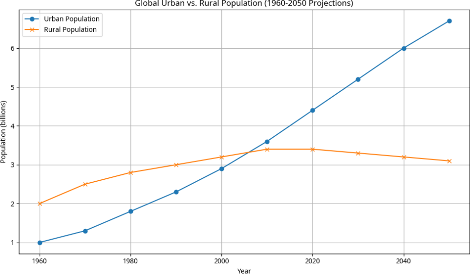
Figure 1: Global Urban vs. Rural Population (1960-2050 Projections). Data based on UN Population Division and Our World in Data.
As depicted in Figure 1, the urban population has steadily increased over the decades, surpassing the rural population around 2007. This trend is projected to continue, with the urban population growing significantly while the rural population stabilizes or slightly declines. This demographic shift underscores the escalating importance of effective urban planning and the critical need for sustainable development strategies to accommodate the growing urban populace.
Conclusion: The Future of Urban Planning in a Geospatial World
The journey towards truly smart and sustainable cities is intrinsically linked to the intelligent application of geospatial technologies. As urban populations continue to swell and environmental challenges intensify, the role of sophisticated tools like ArcGIS becomes not just beneficial, but absolutely essential for effective urban planning. The insights gleaned from real-time data, the ability to model complex scenarios in 3D, and the power to engage stakeholders collaboratively are transforming the very fabric of urban development.
ArcGIS provides the foundational platform for a data-driven approach to urban planning, enabling cities to move beyond reactive problem-solving to proactive, predictive, and participatory governance. By integrating diverse data streams—from environmental sensors and traffic flows to demographic shifts and infrastructure performance— planners can gain a holistic understanding of urban dynamics. This comprehensive view is critical for designing cities that are not only economically vibrant but also environmentally resilient and socially equitable.
Looking ahead, the evolution of ArcGIS and its integration with emerging technologies such as artificial intelligence (AI), machine learning (ML), and the Internet of Things (IoT) will further amplify its capabilities. AI and ML can enhance predictive modeling, automate complex spatial analyses, and identify optimal solutions for urban challenges. IoT devices will continue to expand the volume and variety of real-time data available, providing an ever-more granular understanding of urban environments. This convergence will lead to more intelligent urban systems that can adapt and respond dynamically to changing conditions.
Ultimately, leveraging ArcGIS for urban planning in smart cities is about more than just technology; it is about fostering a new paradigm of urban governance. It is about empowering planners with the tools to create healthier, more efficient, and more livable urban spaces for all. By embracing a geospatial approach to sustainable development, cities can navigate the complexities of urbanization, mitigate environmental impacts, and build a future where technology serves as a catalyst for a truly sustainable and prosperous urban world.
Beat Your Deadline
Hire a Writer Today!
✅ Get Your Assignment Done by Experts
References
- Andersen, L. E., et al. (2019). Copenhagen: Green, Smart and Liveable. Danish Architectural Press.International Energy Agency (IEA). (2021).
- Empowering Urban Energy Transitions. Retrieved from https://www.iea.org/reports/empowering-urban-energy-transitions
- Joo, S. H., & Kim, Y. (2016). Smart City Development in Korea: The Case of Songdo. KDI School of Public Policy and Management.
- United Nations. (2018). World Urbanization Prospects: The 2018 Revision. Retrieved from https://population.un.org/wup/
Leave a Reply